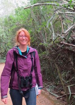
Jessica L. O'Connell - Assistant Professor
Colorado State University
Jessica is an Assistant Professor in the Department of Ecosystem Science and Sustainability at Colorado State University. Her research is centered on landscape ecology and relies on interdisciplinary methods that span the fields of ecology, remote sensing, geospatial informatics, and data science. Her goals are to create research products that facilitate landscape-scale ecosystem conservation. Jessica is a proponent of the open-science philosophy and strives to conduct research that reduces the barriers to accessing scientific results and products. She is also a proponent of long-term ecological research and serves as a Co-PI on the Georgia Coastal Ecosystems Long-Term Ecological Research Project (GCE-LTER).
Department Profile CV Contact
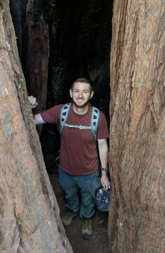
Kyle Runion - PhD Candidate
NASA FINESST Fellow, NOAA Davidson Fellow
University of Texas at Austin
Kyle is interested in coastal resilience and in combating climate-change related stressors on wetlands. He joined UTMSI in January 2021 as a PhD student in Marine Science and studies landscape-scale wetland dynamics through remote sensing techniques. Prior to joining the O'Connell Landscape Modeling Lab, he researched the beneficial use of dredge material for the purpose of wetland restoration with the U.S. Army Corps of Engineers and in his home state of Maryland, Kyle worked with the Chesapeake Bay Program in watershed-scale habitat restoration. He holds a M.S. degree in Marine Studies from the University of Delaware where his thesis research focused on understanding sediment transport in a recently restored tidal salt marsh and a B.S. degree in Environmental Science and Technology from the University of Maryland. Wetland research allows Kyle to combine his passions of nature and data science to promote ecosystem resilience.
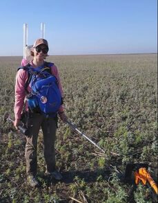
Megan Podolinsky - PhD student
CSU Vice President for Research Graduate Fellow
Colorado State University
Megan Podolinsky is interested in ecosystem dynamics across landscapes, especially restored wetlands and how different land use practices can potentially mitigate the effects of climate change. She joined the O'Connell Landscape modeling lab in June of 2022. Prior to that, Megan worked for over a decade for various government agencies including the U.S. Forest Service, U.S. Fish and Wildlife, and the National Park Service, as well as in the private sector, on wetland delineations and permitting for a small environmental consulting firm. She earned both a B.S. in Environmental Science and a B.A. in Hispanic Studies from Montana State University in Bozeman, Montana in 2012. Megan has been enjoying her summer field season sampling playa wetlands on Conservation Reserve Program land in western Kansas.

Alan Cai - PhD Student
Colorado State University
Alan is interested in the conservation and restoration of aquatic ecosystems. He joined the Landscape Modeling lab in Spring 2024 as a Watershed Sciences PhD student, and studies tidal marsh dynamics and resilience. He has a M.S. degree in Environmental Systems from the University of California, Merced, as well as a B.S. in Environmental Sciences and a B.A. in Atmospheric Science from UC Berkeley. Previously, he has worked on wet meadow restoration monitoring in California, and researched the ecological management of Western U.S. rivers. He is excited to develop new insights about tidal marsh carbon cycling, flooding dynamics, and phenology.
Jackson Akin - MS Student
Colorado State University
Jackson is interested in studying wetland ecosystems and their relationships with climate change and local flora and fauna. He graduated from Colorado State University with a B.S. in Fish, Wildlife and Conservation Biology, where he also completed a capstone research project studying Spiny Orb Weaver Spiders and their relationship with human disturbance. Prior to joining the O’Connell Lab, Jackson worked for the USDA’s Agricultural Research Service studying plant-herbivore interactions, specifically, livestock’s long term grazing effects on rangeland ecosystems. He is very excited to join the lab and for the opportunity to contribute to this important research.
Maggie Church - MS Student
Colorado State University
Maggie Church is passionate about combining her love of nature and data science to inform land management decisions. She is interested in using remotely sensed data to study habitat dynamics. Before joining the O’Connell Landscape Modeling Lab, she worked as a lab assistant in the Sibold Biogeography lab at Colorado State University where she studied the effects of forest disturbance and regeneration. Prior to that, she served as a data analyst at the National Center for Missing and Exploited Children. Maggie earned her B.S. in Economics and Statistics from the University of Pittsburgh in 2017. She is currently collaborating with Ducks Unlimited on a project within the lab to estimate surface water area in Prairie Pothole wetlands.
Christina Marconi - PhD student in the Trophic Ecology Lab
University of Texas, Co-funded by the Landscape Modeling Lab
Christina Marconi is interested in using molecular techniques to explore marine biodiversity and trophic interactions. She joined UTMSI in April 2022 as a PhD student in Marine Science. Before joining UTMSI, Christina worked at the Mission-Aransas National Estuarine Research Reserve as a research scientist in the Stewardship sector. She earned her Master’s in Marine Conservation from the University of Miami in 2018 and a B.S. in Natural Resources with a concentration in Fisheries and Wildlife Conservation from the University of Connecticut in 2016. Christina is currently working with the O’Connell Wetland Landscape Ecology Lab on a project to create open-source algorithms that map coastal wetlands in South Texas. These should help to evaluate habitat change over time and inform decision-making.
Lab Alumni
Postdoctoral Researchers, University of Texas at Austin: Saket Gowravaram, Hossein Sahour
|
|